As we write up our research, we discover many types of material that add context to our family’s story. In 2026, GSQs Writing Group will consider how best to integrate that material into our overall story so that we add context without distracting too much from the story we wish to tell. Different types of material may also help to shape a story. At our February 2026 meeting, we considered maps. Members were invited to write a story that included, or made reference to, a map. The variety and excellence in the use of maps for research or in writing was illustrated by members at the meeting. The maps included hand-drawn mud maps, maps enhanced with annotations and maps used to identify the location of events on land and at sea.
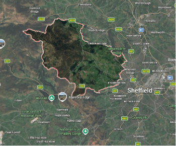
The story I chose to share related to a recent project to research the soldiers commemorated on a WW1 memorial in my home town in South Derbyshire. One prominent local family, whose family business manufactured clay pipes, not only lost two young sons in fighting on the Western Front, but also suffered the death of the mother and the father in quick succession. Research into the origins of this family in census and civil registration records, revealed that the family originated in Yorkshire and north Derbyshire. Accessing a map of places named in these records showed that Wortley, Storrs and Ecclesfield were situated in Bradfield parish in the West Riding of Yorkshire, and Bamford, or Bamforth, was located in Derbyshire. Despite officially lying in two different counties, the areas were close, situated as they were on either side of the county boundary.
Bradfield Parish in Yorkshire is one of the largest parishes in England and its parish records date back to 1559. Helpful maps of the parish and availability of parish records can be found in the Phillimore Atlas & Index of Parish Registers. It lies on the western edge of Sheffield, a city I lived in prior to moving to Australia. Sheffield is renowned for its steel industry, especially in the production of cutlery. Bradfield is situated on the edge of the Peak District National Park, which lies mainly in Derbyshire where Bamford is located. It is primarily a vast open rural area intersected by peaks, moors, small towns, valleys and reservoirs, completely different from the industrial hub of Sheffield.
The Bradfield Parish population was mainly engaged in agricultural and rural occupations. As well as farming, however, several generations of the family had engaged in brickmaking and clay manufacture. Understanding the nature of the landscape, particularly the availability of clay that was suitable for clay pipe manufacture, supported my theory that the family relocated to South Derbyshire, where similar conditions existed, rather than to Sheffield.
Including maps of the relevant area, it was possible to gauge distances between various places, the jurisdictions which governed civil and parish records and how likely it was that people would move between several places at a time when transport options were limited. In any story of this family, I would ensure that the source of the map was appropriately acknowledged and highlight the unlikely development of major industrial or urban areas in this rural and agricultural part of the Peak District National Park. This landscape differed from the landscape in which Sheffield developed.
Some of the types of maps that could be relevant to your family story have been broadly classified into reference maps that show location, boundaries, and features, and thematic maps that represent specific data such as political, physical, topographic, climate, economic, road, and population maps.
(https://www.worldatlas.com/geography/what-are-the-different-types-of-maps.html)
Some points to consider when integrating maps into a family story include the need to take into account the relevance or importance of the map to the story. The higher the relevance to the story will influence the type of map, its size, placement and level of detail.
Other points to take into account are:
- Place maps close to the text to which they relate
- Ensure that all details on the maps are readable and clear
- Include the reference for the map, or acknowledge the source
- Include a key to explain additions and/or highlights on a map
- Include a north point to help with orientation of the map
- Where possible choose maps produced at the time you are writing about.
GSQ has an excellent collection of maps that members are encouraged to explore. Search the catalogue to discover what is available. Each map is numbered and a list is in a folder in each drawer of the map cabinet. Details of various sources for maps were circulated to members of the Group.
Throughout 2026 the Writing Group will consider other types of material that can add context to family stories, such as historical events, different writing genres, family heirlooms and family events and how these can best be integrated into a family story. I will share the Group’s ideas in future posts.
Leave a Reply